


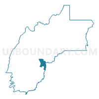
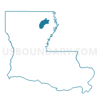
Precinct 5, Richland Parish, Louisiana
About
Outline

Summary
| Unique Area Identifier | 590374 |
| Name | Precinct 5 |
| County | Richland Parish |
| State | Louisiana |
| Area (square miles) | 6.20 |
| Land Area (square miles) | 5.92 |
| Water Area (square miles) | 0.28 |
| % of Land Area | 95.41 |
| % of Water Area | 4.59 |
| Latitude of the Internal Point | 32.33531930 |
| Longtitude of the Internal Point | -91.78308210 |
Maps

Graphs
Select a template below for downloading or customizing gragh for Precinct 5, Richland Parish, Louisiana


Neighbors
Neighoring Voting District (by Name) Neighboring Voting District on the Map
- Precinct 2, Richland Parish, LA
- Precinct 3, Richland Parish, LA
- Precinct 30, Franklin Parish, LA
- Precinct 33, Franklin Parish, LA
- Precinct 4, Richland Parish, LA
- Precinct 9, Richland Parish, LA
Top 10 Neighboring County Subdivision (by Population) Neighboring County Subdivision on the Map
- District 6, Franklin Parish, LA (3,209)
- District 7, Richland Parish, LA (2,279)
- District 9, Richland Parish, LA (2,060)